Contributions to this post were provided by the Voxel51 team. At the Computing Community Consortium (CCC) we know that everyone is dealing with a lot in these unprecedented times. We are continuing to work on behalf of the computing research community to catalyze research, but we also want to provide ways to help the community. This blog is from a series of posts about ways computing researchers are using computing to adapt and help in these times. We hope you find something that may help you, either now or in the future.
Empty parks, X’s taped to the floor in check-out lines, virtual family holidays, these are all part of the new norm thanks to COVID-19. One of the most dangerous parts of the virus is how quickly and easily it can spread. Leaders around the world are calling for citizens to stay inside and practice social distancing, but who’s to know if people are abiding by those pleas. Dr. Jason Corso, Professor of Electrical Engineering and Computer Science at University of Michigan, and his team at Voxel51, paused their core business activities of developing an image and video data curation tool for computer vision and data scientists, to aid in the response to the pandemic. Leveraging the startup’s existing video analysis technology, Voxel51 developed the Physical Distancing Index to help track how COVID-19 and preventative measures to contain its spread have impacted human activity around the globe in real time.
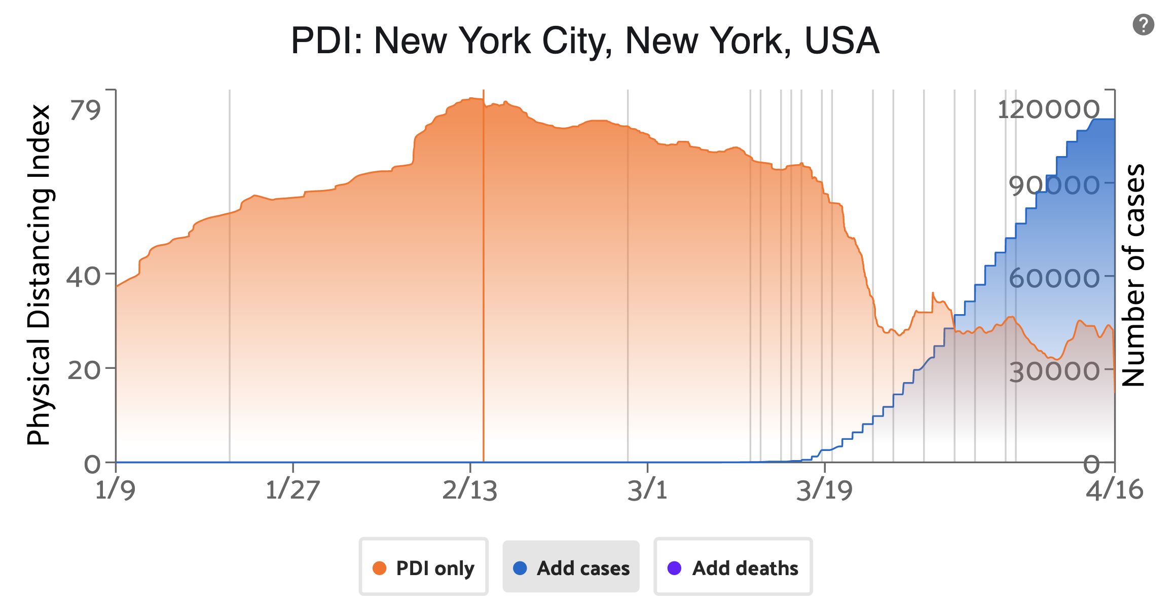
The free AI-powered interactive tool enables users to explore a day-by-day timeline of social activity in some of the world’s most populated areas to track social distancing behaviors. The company’s computer vision and deep learning models detect the number of pedestrians, vehicles, and other human-centric objects in each live stream. A PDI score or the average amount of human activity over the previous 24 hours is automatically calculated every 15 minutes to track the change over time. The PDI score helps people understand and compare how the coronavirus and subsequent policies, news and even factors like number of cases, are changing social behaviors over time. At the moment, Voxel51 gathers and analyzes historical and real time video streams from public street cameras in Ann Arbor, Detroit, Times Square; Abbey Road in London; Fremont Street in downtown Las Vegas; Seaside Heights in New Jersey; a beach in Ft. Lauderdale and intersections in Dublin and Prague.Users can also compare scores across locations to see the differences in PDI relative to each city over time. Corso, described the value of such a tool at this time for the University of Michigan EECS News.

Voxel51’s PDI for New York City, New York.
“This pandemic is having an unprecedented impact on our daily lives and what we’re trying to do is create a tool to improve public awareness,” said Jason Corso, CEO of Voxel51. “The PDI score helps people understand and compare how the coronavirus is changing social behaviors over time and enables municipalities to visualize how they’re doing from a public health perspective.”
Corso led a CCC activity in 2015, focusing on police body worn cameras. This workshop dove into potential benefits of law enforcement incorporating video capture systematically in their day-to-day operations. In many ways, it was a precursor to the current manner in which he and his team use video data to solve today’s problems. Corso and the rest of his team at Voxel51 plan to continue adding locations and plot other metrics, such as weather.. Corso said, “There is even a chance that the PDI can feed into a predictive model for cities not yet greatly affected and the potential for a renewed outbreak next year.” The company is also accepting requests to add locations or specific installations of the system for local government and taxpayer usage.


