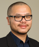
Yao-Yi Chiang
The following Great Innovative Idea is from Yao-Yi Chiang from the University of Southern California. His Querying Historical Maps as a Unified, Structured, and Linked Spatiotemporal Source paper was the first place winner at the Computing Community Consortium (CCC) sponsored Blue Sky Ideas Track Competition at the ACM SIGSPATIAL International Conference on Advances in Geographic Information Systems 2015 (SIGSPATIAL 2015) in Seattle, Washington.
The Innovative Idea
Historical maps hold a great deal of detailed geographic information at various times in the past but finding relevant maps is difficult and the map content are not machine-readable. Using computer algorithms and geospatial technology applications, I am building the techniques to unlock historical information from maps. I envision a map processing, modeling, linking, and publishing framework that allows querying historical map collections as a unified and structured spatiotemporal source in which individual geographic phenomena (extracted from maps) are modeled with semantic descriptions and linked to other data sources (e.g., DBpedia).
Impact
Historical spatiotemporal datasets are important for a variety of studies such as cancer and environmental epidemiology, urbanization, and landscape ecology. By efficiently unlocking to then integrating historical map content with other spatiotemporal source, we will make it possible to efficiently study historical spatiotemporal datasets on a large scale (both in time and space) and solve problems that cannot be easily answered now. For example, we built a computer program, Strabo, that “reads” historical Ordinance Survey maps to quickly generate millions of data “labels” for identifying likely locations of subterranean contamination, such as factories, mines, quarries, and gas works which no longer exist and which otherwise would not be known today. These locations can be used for modeling existing environmental hazards that impact contemporary land uses.
Other Research
Altogether, I am investigating the general techniques for acquiring, modeling, fusion, and visualization of spatiotemporal information from all kinds of sources. In a recent project, I worked with undergraduate students to demonstrate that using place information in historical maps, we can effectively provide rich context for genocide survivors’ life stories in the USC Shoah Foundation Visual History Archive. See an example story map by our USC GeoDesign student Robin Franke here: http://www.arcgis.com/apps/MapJournal/?appid=6c3b4136b9304df09c9adcf86dd30dd5
Researcher’s Background
My research interests lie at the intersection of Computer Science and Spatial Science. I build computer algorithms and applications to solve real world problems in spatial sciences. I work with a group of talented people in USC Spatial Computing.
Links
Personal website: http://yoyoi.info
Group website: http://spatial-computing.github.io
GitHub repositories: https://github.com/spatial-computing
Strabo Tutorial: https://youtu.be/VqdSieR4fxY
Linking Historical Maps to USC Shoah Foundation Visual History Archive: http://www.arcgis.com/apps/MapJournal/?appid=6c3b4136b9304df09c9adcf86dd30dd5 (by Robin Franke) and https://youtu.be/AKbHJO6PjJE (by Andrew Hsu)
To view more Great Innovative Ideas, please click here.


